


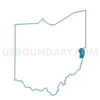
PRECINCT WINTRINGER, Jefferson County, Ohio
About
Outline

Summary
| Unique Area Identifier | 648144 |
| Name | PRECINCT WINTRINGER |
| County | Jefferson County |
| State | Ohio |
| Area (square miles) | 5.20 |
| Land Area (square miles) | 4.94 |
| Water Area (square miles) | 0.26 |
| % of Land Area | 94.91 |
| % of Water Area | 5.09 |
| Latitude of the Internal Point | 40.41376550 |
| Longtitude of the Internal Point | -80.63687900 |
Maps


Graphs
Select a template below for downloading or customizing gragh for PRECINCT WINTRINGER, Jefferson County, Ohio


Neighbors
Neighoring Voting District (by Name) Neighboring Voting District on the Map
- Voting District 17, Hancock County, WV
- Voting District 25, Brooke County, WV
- PRECINCT PLEASANT HILL 1, Jefferson County, OH
- PRECINCT PLEASANT HILL 2, Jefferson County, OH
- PRECINCT STEUBENVILLE 3-3, Jefferson County, OH
- PRECINCT STEUBENVILLE 4-3, Jefferson County, OH
- PRECINCT STEUBENVILLE 5-2, Jefferson County, OH
- PRECINCT STEUBENVILLE 6-2, Jefferson County, OH
- PRECINCT WELSMAR, Jefferson County, OH
Top 10 Neighboring County Subdivision (by Population) Neighboring County Subdivision on the Map
- Steubenville city, Jefferson County, OH (18,659)
- Island Creek township, Jefferson County, OH (10,546)
- Clay district, Hancock County, WV (10,092)
- Weirton district, Brooke County, WV (7,919)
Top 10 Neighboring Place (by Population) Neighboring Place on the Map
Top 10 Neighboring Unified School District (by Population) Neighboring Unified School District on the Map
- Hancock County School District, WV (30,676)
- Brooke County School District, WV (24,069)
- Steubenville City School District, OH (16,157)
- Edison Local School District, OH (15,355)
Top 10 Neighboring State Legislative District Lower Chamber (by Population) Neighboring State Legislative District Lower Chamber on the Map
- State House District 95, OH (106,820)
- State House District 2, WV (34,538)
- State House District 1, WV (32,812)
Top 10 Neighboring State Legislative District Upper Chamber (by Population) Neighboring State Legislative District Upper Chamber on the Map
Top 10 Neighboring 111th Congressional District (by Population) Neighboring 111th Congressional District on the Map
Top 10 Neighboring Census Tract (by Population) Neighboring Census Tract on the Map
- Census Tract 311.01, Brooke County, WV (5,213)
- Census Tract 114.01, Jefferson County, OH (4,292)
- Census Tract 114.02, Jefferson County, OH (4,046)
- Census Tract 14, Jefferson County, OH (3,792)
- Census Tract 214, Hancock County, WV (3,637)
- Census Tract 213, Hancock County, WV (3,376)
- Census Tract 2, Jefferson County, OH (3,035)